Cafe nearby Herbalife Daniel
Coronavirus disease (COVID-19) Situation
confirmed cases
1212131
deaths
22407
Bolivia
Cafe nearby Herbalife Daniel
Herbalife Daniel
25 de Mayo, Cochabamba, Cercado, BO Bolivia
contacts phone
:
+591 72743094
Latitude:
-17.3955999
, Longitude:
-66.1549526
larger map & directions
read more
nearest Cafe
168 m
El Pahuichi Salon De Te
esteban arze entre y jordan, Sucre
Cafe
read more
178 m
Wist'upiku
Sucre 434, Cochabamba
Cafe
read more
183 m
Espresso Cafe Bar
Cochabamba
Cafe
read more
225 m
KE CHURROS
Nataniel Aguirre, Cochabamba
Cafe
read more
274 m
La Bambola
591, Jordan 558, Cochabamba
Cafe
read more
319 m
Reposteria Rossy
Sucre, Cochabamba
Cafe
read more
386 m
Cafetería El Turista.
Avenida Ayacucho, Cochabamba
Cafe
read more
437 m
Cafe lea Mas
Cochabamba
Cafe
read more
480 m
Café Ideal Bolivia Cochabamba
General Achá 128, Cochabamba
Cafe
read more
663 m
Café el Griego
Ecuador, Cochabamba
Cafe
read more
713 m
La Pascana Salón de Té
Colombia E-950, Cochabamba
Cafe
read more
717 m
Salon De Te Mosita Camba
Ecuador, Cochabamba
Cafe
read more
728 m
Kipus Librería Café
Cochabamba
Cafe
read more
730 m
Cocafé Arte
Cochabamba
Cafe
read more
753 m
Café TAU
Cochabamba
Cafe
read more
770 m
Café Caracol
Mayor Rocha, Cochabamba
Cafe
read more
793 m
Ciudad de Refugio (CDR)
Ecuador, Cochabamba
Cafe
read more
808 m
Café Ideal
Cochabamba
Cafe
read more
873 m
Armonia Centro Coffee Club
Cochabamba
Cafe
read more
938 m
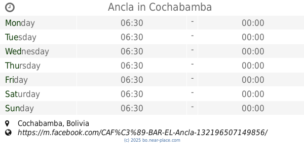
Ancla
Cochabamba
Cafe
read more
970 m
Pro Pic
Avenida Huayna Kapac, Cochabamba
Cafe
read more
1.004 km
Cowork express
Cochabamba
Cafe
read more
1.037 km
Toc Toc Cafe
Mariano Baptista, Cochabamba
Cafe
read more
1.084 km
Ma
Ayllu, Cochabamba
Cafe
read more
1.157 km
Cafe Milano Bistro
Junin, Cochabamba
Cafe
read more
📑
all categories
Accounting
Administrative area level 1
Administrative area level 2
Airport
Amusement park
Aquarium
Art gallery
Atm
Bakery
Bank
Bar
Beauty salon
Bicycle store
Book store
Bowling alley
Bus station
Cafe
Campground
Car dealer
Car rental
Car repair
Car wash
Casino
Cemetery
Church
City hall
Clothing store
Colloquial area
Convenience store
Courthouse
Dentist
Department store
Doctor
Electrician
Electronics store
Embassy
Finance
Fire station
Florist
Food
Funeral home
Furniture store
Gas station
General contractor
Grocery or supermarket
Gym
Hair care
Hardware store
Health
Hindu Temple
Home goods store
Hospital
Insurance agency
Jewelry store
Laundry
Lawyer
Library
Light rail station
Liquor store
Local government office
Locality
Locksmith
Lodging
Meal delivery
Meal takeaway
Mosque
Movie rental
Movie theater
Moving company
Museum
Natural feature
Neighborhood
Night club
Painter
Park
Parking
Pet store
Pharmacy
Physiotherapist
Place of worship
Point of interest
Police
Political
Post office
Premise
Real estate agency
Restaurant
Roofing contractor
Route
Rv park, camping
School
Shoe store
Shopping mall
Spa
Stadium
Storage
Store
Subway station
Supermarket
Synagogue
Taxi stand
Train station
Transit station
Travel agency
University
Veterinary care
Zoo
administrative area level 4
sublocality level 1
↑