Cafe nearby Big Boys
Bolivia
Cafe nearby Big Boys
Big Boys
Cochabamba, Bolivia
contacts phone
:
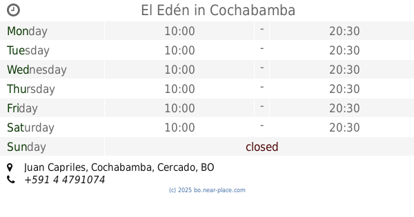
+591
Latitude:
-17.3806017
, Longitude:
-66.1657153
larger map & directions
read more
nearest Cafe
149 m
Heladería Colonial España
Cochabamba
Cafe
read more
149 m
Gelateria Colonial Spain
Cochabamba
Cafe
read more
153 m
Pasteleria Elida
Cochabamba
Cafe
read more
810 m
Santino Cafetería
Alcides Arguedas, Cochabamba
Cafe
read more
828 m
Club de Bienestar Hipermaxi El Prado (Nutricion Herbalife)
Cochabamba
Cafe
read more
864 m
Cafe Milano Bistro
Junin, Cochabamba
Cafe
read more
914 m
Capresso Sucursal Simeon Roncal America
Cochabamba
Cafe
read more
948 m
Funky Churros
Avenida América 412, entre Enrique Arze y Héctor Cossio, Cochabamba
Cafe
read more
964 m
MI DULCE OLIVIA
Aniceto Padilla, Cochabamba
Cafe
read more
970 m
Capresso Café
Avenida América, Cochabamba
Cafe
read more
977 m
The break coffe time
Tomas Oconor, Cochabamba
Cafe
read more
1.006 km
Cratos
Mariano Baptista, Cochabamba
Cafe
read more
1.023 km
Cafe Gourmet Toc Toc
Mariano Baptista & Jose de La Reza, Cochabamba
Cafe
read more
1.023 km
Cafe Gourmet Toc Toc
Mariano Baptista, Cochabamba
Cafe
read more
1.023 km
Toc Toc Cafe
Mariano Baptista, Cochabamba
Cafe
read more
1.055 km
Ke Churros
Avenue Portales, Cochabamba
Cafe
read more
1.063 km
Take Coffe (Cafe Nescafé)
Cochabamba
Cafe
read more
1.135 km
Rellenos Calama Junior
Avenida D'Orbigni, Cochabamba
Cafe
read more
1.231 km
Café Tinto
Mexico, Cochabamba
Cafe
read more
1.235 km
Tambo Cafe y Cultura
Cochabamba
Cafe
read more
1.269 km
Oasis de Dalí
España 429, Cochabamba
Cafe
read more
1.287 km
Café Caracol
Mayor Rocha, Cochabamba
Cafe
read more
1.299 km
Café Ideal
Cochabamba
Cafe
read more
1.301 km
El Edén
Juan Capriles, Cochabamba
Cafe
read more
1.324 km
Capreso
Cochabamba
Cafe
read more
📑
all categories
Accounting
Administrative area level 1
Administrative area level 2
Airport
Amusement park
Aquarium
Art gallery
Atm
Bakery
Bank
Bar
Beauty salon
Bicycle store
Book store
Bowling alley
Bus station
Cafe
Campground
Car dealer
Car rental
Car repair
Car wash
Casino
Cemetery
Church
City hall
Clothing store
Colloquial area
Convenience store
Courthouse
Dentist
Department store
Doctor
Electrician
Electronics store
Embassy
Finance
Fire station
Florist
Food
Funeral home
Furniture store
Gas station
General contractor
Grocery or supermarket
Gym
Hair care
Hardware store
Health
Hindu Temple
Home goods store
Hospital
Insurance agency
Jewelry store
Laundry
Lawyer
Library
Light rail station
Liquor store
Local government office
Locality
Locksmith
Lodging
Meal delivery
Meal takeaway
Mosque
Movie rental
Movie theater
Moving company
Museum
Natural feature
Neighborhood
Night club
Painter
Park
Parking
Pet store
Pharmacy
Physiotherapist
Place of worship
Point of interest
Police
Political
Post office
Premise
Real estate agency
Restaurant
Roofing contractor
Route
Rv park, camping
School
Shoe store
Shopping mall
Spa
Stadium
Storage
Store
Subway station
Supermarket
Synagogue
Taxi stand
Train station
Transit station
Travel agency
University
Veterinary care
Zoo
administrative area level 4
sublocality level 1
↑