Cafe nearby Café Capital
Bolivia
Cafe nearby Café Capital
Café Capital
Aniceto Arce, Sucre, Provincia de Samuel Oropeza, BO Bolivien
contacts phone
:
+591
Latitude:
-19.0470154
, Longitude:
-65.2595133
larger map & directions
read more
nearest Cafe
140 m
Abis Cafe
Plaza 25 de Mayo, Sucre
Cafe
read more
142 m
Pencos Cafe
Junin, Sucre
Cafe
read more
142 m
Café Valentino
Junin, Sucre
Cafe
read more
188 m
CC's cafe,comida y sazon
Junin & Ravelo, Sucre
Cafe
read more
205 m
Frozz
Junin 709, Sucre
Cafe
read more
207 m
FORUM LECAFE
Casco Viejo, Sucre
Cafe
read more
219 m
Bien Chevere Cafe
Audiencia 17, Sucre
Cafe
read more
224 m
Las Delicias
Estudiantes, Sucre
Cafe
read more
256 m
Condortrekkers & Condor Café
Bolivar &, Calvo, Sucre
Cafe
read more
256 m
Coffee Click
Ravelo, Sucre
Cafe
read more
281 m
Berries Cream
Casco Viejo, Sucre
Cafe
read more
289 m
Adrissa TrueTaste
casi, Camargo, Sucre
Cafe
read more
308 m
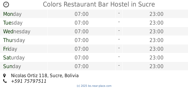
Colors Restaurant Bar Hostel
Nicolas Ortiz 118, Sucre
Cafe
read more
382 m
CAFETERIA TARTA TATIN
Avaroa 337, Sucre
Cafe
read more
384 m
Cafe Momentos Felices
Casco Viejo, Sucre
Cafe
read more
443 m
Coffee Black
Grau, Sucre
Cafe
read more
478 m
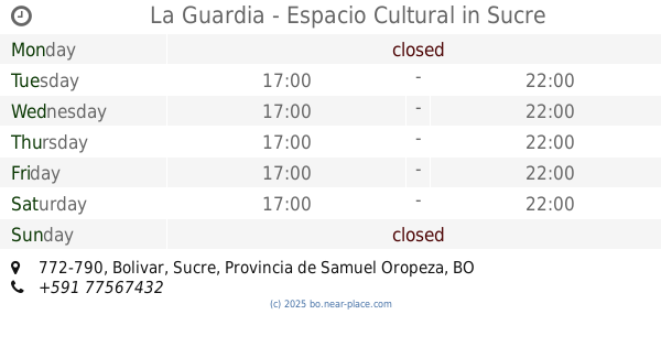
La Guardia - Espacio Cultural
Bolivar 772-790, Sucre
Cafe
read more
574 m
Karinel
Juan Jose Perez, Sucre
Cafe
read more
585 m
Café Time&Coffee
Km. 7, Sucre
Cafe
read more
647 m
El Aljibe Café
591, Sucre
Cafe
read more
666 m
Yucatán Paletas Mexicanas
Juan Jose Perez 301, Sucre
Cafe
read more
674 m
CAFE CHOCOLATE CAFE
Colon 755, Sucre
Cafe
read more
719 m
La Patisserie
Grau 464, Sucre
Cafe
read more
765 m
PECAS
Pastor Sainz, Sucre
Cafe
read more
957 m
Salteñeria Cuba
Avenida Chuquisaca 172, Sucre
Cafe
read more
📑
all categories
Accounting
Administrative area level 1
Administrative area level 2
Airport
Amusement park
Aquarium
Art gallery
Atm
Bakery
Bank
Bar
Beauty salon
Bicycle store
Book store
Bowling alley
Bus station
Cafe
Campground
Car dealer
Car rental
Car repair
Car wash
Casino
Cemetery
Church
City hall
Clothing store
Colloquial area
Convenience store
Courthouse
Dentist
Department store
Doctor
Electrician
Electronics store
Embassy
Finance
Fire station
Florist
Food
Funeral home
Furniture store
Gas station
General contractor
Grocery or supermarket
Gym
Hair care
Hardware store
Health
Hindu Temple
Home goods store
Hospital
Insurance agency
Jewelry store
Laundry
Lawyer
Library
Light rail station
Liquor store
Local government office
Locality
Locksmith
Lodging
Meal delivery
Meal takeaway
Mosque
Movie rental
Movie theater
Moving company
Museum
Natural feature
Neighborhood
Night club
Painter
Park
Parking
Pet store
Pharmacy
Physiotherapist
Place of worship
Point of interest
Police
Political
Post office
Premise
Real estate agency
Restaurant
Roofing contractor
Route
Rv park, camping
School
Shoe store
Shopping mall
Spa
Stadium
Storage
Store
Subway station
Supermarket
Synagogue
Taxi stand
Train station
Transit station
Travel agency
University
Veterinary care
Zoo
administrative area level 4
sublocality level 1
↑