Cafe nearby Manjar de Oro Chocobar
Bolivia
Cafe nearby Manjar de Oro Chocobar
Manjar de Oro Chocobar
Queru Queru, Cochabamba, Bolivia
contacts phone
:
+591 4 4485899
website:
manjardeoro.com
Latitude:
-17.3734192
, Longitude:
-66.1491711
larger map & directions
read more
nearest Cafe
254 m
Mangos Juice Bar
Cochabamba
Cafe
read more
277 m
Cocolatte
Cochabamba
Cafe
read more
300 m
Coffee House
Avenida Portales, Cochabamba
Cafe
read more
306 m
Coffee shop Lattente
Av América 753-607, Cochabamba
Cafe
read more
366 m
Salón de Té Para Ti
Cochabamba
Cafe
read more
445 m
Capresso Café
Avenida Pando, Cochabamba
Cafe
read more
511 m
De Café
Avenida Pando, Cochabamba
Cafe
read more
545 m
Gourmet Coffee
Buenos Aires, Cochabamba
Cafe
read more
566 m
More Coffee Shop
Av Uyuni & Blvrd de la Recoleta & Av Melchor Urquidi, Cochabamba
Cafe
read more
566 m
More Coffee Shop
Avenida Uyuni, Cochabamba
Cafe
read more
568 m
La Abuelita Ruth
Pasaje Portales, Cochabamba
Cafe
read more
610 m
Mon Chéri Café
Cochabamba
Cafe
read more
611 m
Baretto Cafe
Beni, Cochabamba
Cafe
read more
655 m
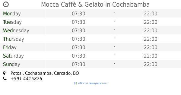
Mocca Caffè & Gelato
Potosi, Cochabamba
Cafe
read more
655 m
Mocca Caffè & Gelato
Potosi & Beni, Cochabamba
Cafe
read more
669 m
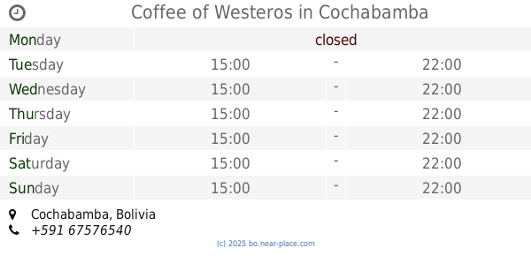
Coffee of Westeros
Cochabamba
Cafe
read more
780 m
La Cafettera
Potosi, Cochabamba
Cafe
read more
796 m
Café Havanna
Cochabamba
Cafe
read more
796 m
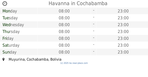
Havanna
Cochabamba
Cafe
read more
796 m
HAVANNA Asturia Café
Avenida Ramón, Rivero, Avenida Ramón Rivero, Cochabamba
Cafe
read more
835 m
Mafin's Reposteria
Beni 447, Cochabamba
Cafe
read more
895 m
Caffé Venezia
Av. Santa Cruz esquina Ciclovía, Cochabamba
Cafe
read more
920 m
Ke Churros
Avenue Portales, Cochabamba
Cafe
read more
983 m
MI DULCE OLIVIA
Aniceto Padilla, Cochabamba
Cafe
read more
995 m
The break coffe time
Tomas Oconor, Cochabamba
Cafe
read more
📑
all categories
Accounting
Administrative area level 1
Administrative area level 2
Airport
Amusement park
Aquarium
Art gallery
Atm
Bakery
Bank
Bar
Beauty salon
Bicycle store
Book store
Bowling alley
Bus station
Cafe
Campground
Car dealer
Car rental
Car repair
Car wash
Casino
Cemetery
Church
City hall
Clothing store
Colloquial area
Convenience store
Courthouse
Dentist
Department store
Doctor
Electrician
Electronics store
Embassy
Finance
Fire station
Florist
Food
Funeral home
Furniture store
Gas station
General contractor
Grocery or supermarket
Gym
Hair care
Hardware store
Health
Hindu Temple
Home goods store
Hospital
Insurance agency
Jewelry store
Laundry
Lawyer
Library
Light rail station
Liquor store
Local government office
Locality
Locksmith
Lodging
Meal delivery
Meal takeaway
Mosque
Movie rental
Movie theater
Moving company
Museum
Natural feature
Neighborhood
Night club
Painter
Park
Parking
Pet store
Pharmacy
Physiotherapist
Place of worship
Point of interest
Police
Political
Post office
Premise
Real estate agency
Restaurant
Roofing contractor
Route
Rv park, camping
School
Shoe store
Shopping mall
Spa
Stadium
Storage
Store
Subway station
Supermarket
Synagogue
Taxi stand
Train station
Transit station
Travel agency
University
Veterinary care
Zoo
administrative area level 4
sublocality level 1
↑